Friday, July 27, 2018

WATERFALLS & HORSES - DAY 2 -


The second day of our 3 day expensive tour of SW Iceland, we boarded 3 "Superjeeps" to begin our ride.  Unfortunately we ended in the back of one, a bouncy ride with very little view out of the windows - not the best to someone with back problems and camera in hand.  But there we were so I made the best of it. 
 The good (or bad) part of it was that was we seemed to travel over some of the same roads as the day before.                                                                               


The "marshmellow" fields with grasses wrapped tightly in white (though sometimes in pink, light blue of black) plastic ready to feed the animals during the cold season.


The rich green countryside with purple lupine and mountains and rivers in the background.

The smooth deposit of ash from many volcanic eruptions covered with vegetation and bordered by trees.

And the steep fronts of mountains and cliffs laced with waterfalls

We circled large fjords such as the Whale Fjord or Hvalfjörður a 30 km long fjord surrounded by volcanic mountains and green terrain in the summer months.

This beautiful Fjord was used by British and US troops during the 2nd WW as a Naval Base, and the remains can be seen today.

On the fjord is Iceland’s only operational whaling station, operated by Hvalur Ehf., which makes use of one of the piers that the US Navy had built.  In my mind it is still one too many

The LAVA Center, which was opened in June 2017, an interactive high-tech educational exhibit
depicting volcanic activity, earthquakes  and the creation of Iceland over millions of years. 
The museum is located in town of Hvolsvöllur, , and is within viewing distance of three volcanoes: Katla, Hekla, and Eyjafjallajökull, which shut down European airspace when it erupted in 2010.


On out way to a delicious lunch at the Country Inn Anna, we passed these old houses buried in the ground. They must have been warmer in the winter if the snow didn't come this high.

These horses were a few of the ones on the hills above where we had lunch.  In Iceland there are about 80,000 horses (compared to about 317,000 humans) and about 100,000 abroad.  For centuries Icelandic horses have lived half wild and half tame. In the summer farmers drive them to the highlands, where they live without human care for months.  Icelandic Horses are
in great demand, and though they can be sold and exported, none can be imported.  The stock is pure and healthy, and the government intends to keep it that way.

This old hut above the restaurant where we ate took my interest.  Wonder if it was once a house, or if it was a shelter for animals?

We stopped  at this massive glacier called Solheimajokull, where some of the group (not us) went for a walk on the glacier.  Having done this on the Mendenhall Glacier in Alaska years ago, this dirty one didn't interest me, particularly in the rain.

The run-off made for interesting patterns in the "parking lot" though.

What did interest me though was this beautiful, majestic waterfall nearby called Skogafoss.


Skogafoss is a magnificent waterfall, 45 feet wide and 200 feet wide situated on the Skógá River in the south of Iceland at the cliffs of the former coastline. After the coastline had receded seaward (it is now at a distance of about  3.1 miles from Skógar.  The former sea cliffs remained, parallel to the coast over hundreds of kilometres, creating together with some mountains a clear border between the coastal lowlands and the Highlands of Iceland.  There is a legend, the first Viking settler in the area, Þrasi Þórólfsson, buried a treasure in a cave behind the waterfall. The legend continues that locals found the chest years later, but were only able to grasp the ring on the side of the chest before it disappeared again. The ring was allegedly given to the local church. The old church door ring is now in the Skógar museum.

Going on we passed this "Pile" of cows happily resting near the road.

 
  And this family of sheep safely nestled among the rocks.


The Seljalandsfoss waterfall is one of the highest waterfalls in Iceland.  It is fed by melting water from the famed glacier-capped Eyjafjallajokull volcano.  What makes it so unusual is that you can walk behind it.


In the background here you can see people starting to walk behind the falls.

I was content with the beautiful plants and flowers along the river.

We passed this group of horses by the road, including one very curious colt.

This field was completely mowed and packed away for later use.

This rushing river was spanned by an interesting bridge, pedestrian?

Another Idealistic scene, a rd roofed church with the rugged mountains in the background.

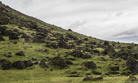
This hillside strewn with large boulders shows the debris from a recent volcanic eruption.
 
A welcome gift from the United states, a relatively new power plant.

And the last photo from this busy day, the tourists standing atop the rift  at the pingvellir National Park, a UNESCO World Heritage Site.  But that I will leave for tomorrow, our 3nd and last day in
Iceland,  Do you think the sun will shine??  NO!!


Wednesday, June 27, 2018

LAST DAY OF 3 DAY TOUR

The last day we were picked up from our hotel by bus, (thankfully) and driven to the Thingvallir National Park, a UNESCO World Heritage Site in the Rift Valley. The park marks the crest of the Mid-Atlantic Ridge and the boundary between the North-American and Eurasian tectonic plates.
Though the ridge extended from the Artic to the Antartic, Iceland is the only place where it is above land and can be seen.
The Park besides being of such Geological importance is also of great cultural and historical importance.  It was founded in 1930 marking the 1000th Anniversary of the Althing, the national parliament of Iceland, which was established at the site in 930 AD.
To the south lies the Thingvallavatn, the largest natural lake in Iceland


The gravel path down the Almannagja Fault extended all  the way to the top until 2011 when on March 31st a hole appeared in the middle of the path. After investigation a larger and deeper fault was discovered almost 10 meters deep.  The hole was probably caused when a large boulder and layer of rocks and gravel fell deeper into the crevice loosened by the 2000 and 2008 earthquakes.  The decision to build a wooden footbridge on top of the rift was, I thought  a good one.

As we continued to descend to the gravel path I was glad to not know that story yet.

Green grass took over, and moss and vegetation began to appear on the rock walls.  This, I assume was the area where the council set up their temporary dwellings with walls of turf and rock and roofing of homespun cloth, though little if any trace remained.

However, the wildflowers were beautiful, and we saw trees appearing now and then.


In the Colorado mountains these beautiful flowers were called Blue Flax, I don't know what they 
were called in Iceland.

As others were taking photos, as was I, I read sign with information about the later uses of this area.
The assembly of Thingvellir (the Alpingi} was Iceland's legislative and chief judicial authority until 1271 when clashes between chieftains families  resulted in Iceland becoming under Norwegian and later Danish rulers.

Over the years the Icelanders gathered here to celebrate their most important festivals. On June 17, 1944, Icelanders flocked to Thingvellir for the foundation of the modern republic of Iceland, which had been delayed due to occupation during World War II.

These beautiful waters were became in ancients times a place of execution, especially for women who were drown here.


But, all that aside. what a beautiful spot!

The water goes on, under a natural bridge to join the stream below.

On our way back to Reykjavik we stopped at the Blue Lagoon for a wonderful lunch in the main dining room.  On the way in I couldn't resist these lovely flowers growing in the lava rocks.

And this last look at the famous "Blue Lagoon".

On our way to our hotel in Reykjavik we were able to see the Oxararfoss Waterfall pouring off the
the top of the Rift where the Thingvellir N.P. was located.

With very full stomachs we were driven to the center of town to meet our charming young guide at the National Theater for a walking tour, in the rain of course, and "tastes of Iceland".
.

Our first stop was to try a variety of local beer,
followed by a large bowl of delicious soup
and wonderful fresh bread. I felt bad eating
and drinking so little, but---!


Walking along the street I just had to snap a photo of these Puffins because I backed out of the tour, regretfully, to "Bird Island" nesting place of thousands of these interesting creatures.

The shops and cafes were colorful,

And decorated with local motifs.

This Artic Fox was a beauty, but I would rather have seen him it the wild rather than a window.

If anyone can read this, please let me know.  To me the Icelandic language is beyond my comprehension.

Next our lovely guide took us to this shop an offered us a selection of local cheeses and meats.
I didn't want to know what some of those were.  Horse, for one, I am sure.


The flower pots on street corners were beautifully planted,

And this sign I could actually read and appreciate.


Dominating the end of the main street were these two
impressive  structures, a large statue of the first Viking to settle in Iceland,  and the 73 m
high Hallgrimskirkja, a modern
cathedral build in the Icelandic tradition.


Our final stop on this drizzling, gastronomic tour where we were served desert.

On the 2nd floor, under this mural of Iceland's origin, we were presented with these final sweets.
No calories, of course!!!